|

| Queensland - SOUTHPORT AND THE BROADWATER |
|
| Queensland - SOUTHPORT AND THE BROADWATER |
|
The Gold Coast February 2006
The further north we sailed, the hotter it got! Also the the longer the expanses of beaches.
After |
 |
Southport We entered the seaway passing the Seaway Tower, where VMR perform a great service to mariners. Although they are a volunteer organization, their equipment is state of the art and their towers (one such example pictured right) are very modern. We continued through the pass dodging swimmers, boarders, dinghy sailors and people partaking in all sorts of water activities despite the shark warnings. Turning into the channel we were bombarded with wake from power boats, jet skies, ferries, and sport fishing boats.
Once anchored Eckhart and Ursula invited us for a Sundowner and we caught up on news. We remained at this anchorage enduring extremely hot weather with much higher humidity than I would have expected. It was hard to get motivated to even leave the boat but jumping into the murky water with the sharks did not seem appealing. |
Surfer's Paradise Feb 5, 2006 We took a long dinghy ride to the marinas up the channel where we were able to lock the dinghy to a dinghy dock. We walked for miles into Surfer's Paradise looking for a grocery store but never did find one. |
 |
 |
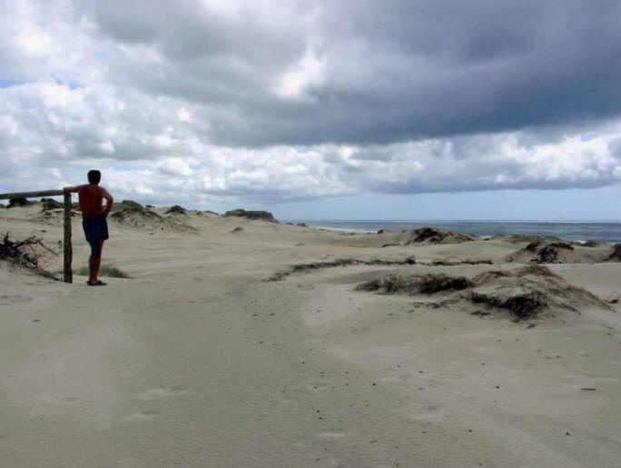
The beach was magnificent, a long 70 km uninterrupted stretch of sandy I was surprised that the beaches were relatively uncrowded.
The water was beautiful but the surf and undertow so strong that it's not especially good for swimming (you can only swim between the flags), however surfers can still enjoy the waves. Evidently but the number of fishermen, fishing from the beach is also good.
|
 |
 |
|
Shark Patrol There are shark fences around all the swimming areas as the sharks are a real threat. A girl was taken down by a Bull shark at Stradbroke Island last week. Helicopters constantly patrol the shoreline on "shark lookout!" It seems strange for us to see this because we have been swimming with the sharks all across the Pacific! |
||
|
The Broadwater To get to Moreton Bay we preferred the inland route, protected from the wind and wave on the outside, but were concerned about our 8 foot draft through the shallow waters. After consulting other cruisers and our charts we decided to attempt it by timing the tides and sticking to the Main Channel.
Feb 12, 2006 After a visit with Rick (Dikenja) we pulled anchor and headed toward the passageway of the Broadwater, the name for the network of shallow estuaries interspersed by low bush covered sand islands. Because it was Sunday the boat traffic was horrendous and we were tossed around by the wake of one power boat after another, our towed dinghy almost being swapped with each passing boat. Then the distant thunder and lightening gave way to rain which came down with such a force as to seriously hamper visibility making it hard to find the marks in the channel. Since it was no longer high tide, it was with much anticipation that we left the Main Channel to head toward our anchorage at South Stradbroke Island. We held our breath as our keel skimmed across the bottom of the channel, our sounder registering only inches over 8 feet at points. We made it into the anchorage just as the rain subsided somewhat. |
||
|
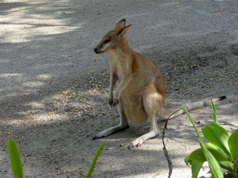
South Stradbroke Island We anchored in front of Tipplers Resort which was still busy with weekenders, swimming, skiing and ripping around on their jet skies despite the dreary weather. But by evening most of the boats had vacated and there was only ourselves and a couple of other houseboats so it was very peaceful. The area is quite beautiful with a sandy shoreline and dense trees hiding a modest resort. On closer look we saw that there were Wallabies hoping along the shoreline and we continued to be entertained by the cute little marsupials all evening long! |
|
 |
Feb 13, 2006
|
 |
After breakfast we ventured ashore where we found a little store that could supply us with bread and milk. We took a sandy trail through the bottlebrush and eucalyptus bush across the island to the surf beach. This beach was another amazing Australian beaches, with a wide span of white sand stretching for miles and miles. We walked down the beach all the way to the pass, about 4 hours and did not see another sole on the beach! |
 |
|
Jumpin Pin There were lots of oyster catchers, terns and other seabirds, and tracks left by the kangaroos. It was far too hot a day for the little critters to be on the beach. The further down the beach we walked the more extensive the sand dunes became, until we felt as though we were walking through the Sahara Dessert. It would have been fun to have had something to slide down the dunes on (sand tobogganing). We finally reached Jumpin Pin which is where Stradbroke Island broke apart years ago to form North and South Stradbroke Islands. |
 |
||||
|
|
|
|||
|
Eventually we crossed over to the other side of the island and cooled off in the river. As we were following the shoreline back to the anchorage we saw wallabies nestled in the shade of the Paperback Trees framing the water. When we looked down Tipplers Passage we realized just how far we had walked. We had a long way to walk to get back to the boat and we were already really hot, very tired, badly sunburned and covered with sandfly bites. After several hours we came to a campground that had a shower and we took advantage of the cool fresh water to rinse off. Unfortunately the water was not fit to drink so we remained thirsty. |
Gord left our mark in the sand, amongst the kangaroo tracks |
|
After several more hours we came to the Southport Yacht Club where we stopped in search of water. There were no facilities except a large picnic area where at least 20 wallabies were obliviously grazing. Kookaburras were perched on the tables so we decided that this would be a great spot to rest a while. The wallabies let me happily snap their pics. |
|
 |
| Finally back at the Resort we were able to quench our thirst, again under the watchful eye of another little wallaby standing beside our picnic table. | ||
|
Feb 14 We were a bit stiff from our overdone walkabout the day before so we just took a short stroll down the beach to visit some more wallabies and check out the campground. There are 45 kinds of wallabies and kangaroos so I am going to make it my project to learn what many of these look like. Somebody from one of the cruise boats left a bag of "wallaby food" on a picnic table and it wasn't long before we had a friendly Swamp Wallaby eating it out of our hands! |
 |
|
Feb 15, 2006 We took the dinghy to Couray Cove Resort, an exclusive new housing development on a spiderweb of canals where each house had a boat dock. The area was almost entirely empty of boats though. The resort was definitely not yachtie friendly as there were signs everywhere prohibiting overnight and transient boats. |
 |
||
| We dinghied along a sand patch of beach and encountered a large red kangaroo grazing
on seaweed at low tide. We stopped to watch him for awhile and after he got tired of
our presence and hopped away we tied the dinghy to a tree and took a trail to the backside of the resort. It was a very interesting complex consisting of ECO-friendly accommodations set on poles protecting the forest. We followed a paved road to the "Environmental Center" where we wondered through an intriguing display of the local plant, floral and fauna of the area. They had information on all kinds of reptiles, mammals, marine plants and animals and insight to South Stradbroke Island. |
|
|
Sand Dunes We continued along the road which took us to the surf beach on the other side of the island. Here a boardwalk traversed the huge sand dunes to protect the fragile environment. The immense stretch of beach was nearly deserted but there was a life guard on duty. We walked back to the resort making way for the shuttle train to c lamber by us empty of passengers. |
 |
|
On our walk back to the dinghy, we stopped to watch a large group of Rugby Roos grazing in the sports field. These were likely the 'Big Reds' as they stood as tall as us!
We also spotted a huge Goanna (Lace Monitor) as it scurried across
the road. |
|
| Since the weekend was encroaching and we knew that our solitude would be short lived, we moved form our idyllic anchorage and set out for Jacob's Well.
Jacob's Well |
|
||
| It was not long before John from Sally Forth came over for a visit. We exchanged DVD's and enjoyed a sundowner together. There wasn't much at Jacob's Well to hold our attention and the no-seeum sand flies absolutely feasted on me the whole time we were there. We kept a mosquito coil burning and put screens in the hatches but the tiny insects got right through. Coupled with my peeling skin from the severe sunburn I got during our long walk on South Stradbroke Island and the hundreds of insect bites, I was feeling worn! I must say that Australia has been the worst place for biting insects that we have encountered so far. |
Macleay Island
Feb 18
Feb 19
Feb 20 Ferry to Mainland Feb 24 Since our food supply was much diminished, we organized ourselves to rise early, take the dinghy ashore, lock it to a tree, and catch the ferry to Redland Bay. It cost us $5.80 each one way. From Redland Bay we caught a bus to Cleveland where we heard there was a good chandlery. Since the best grocery stores were in Victoria Point, we bought an all-day bus pass so we could make a stop for provisions on the way back to Redland. That cost $7.80 for us both. Cleveland is a moderate sized center and had a huge shopping mall with most everything the average person could want. However, yachties are not average and our requests for items like a replacement for my Sony camera indicator, parts for our Radar, a replacement head for our autohelm, watermaker filters, and the list goes on..... were directed to the next town, which was out of our bus pass zone. So we decided to make that trip another day. We did a lot of walking that day, including a stroll along a boardwalk through the Black Swamp Mangroves, where we saw a variety of birds, mostly Ibis. We visited the Tourist Info Center and obtained information for Mom & Dad's upcoming visit to Brisbane. After lunch we caught the bus back to Victoria Point, prepared to do some serious grocery shopping. However, after a stop to search for some electronics at Dick Smiths and another detour to K-Mart for miscellaneous items, we arrived at the supermarket just as it was closing and it was only 5 pm. Oh well, there was 4 other groceries in town, so we lugged our already heavy packs through the city, only to find each store in succession closed. Defeated, we headed back to the ferry dock to return to the boat. We were planning to leave for a remote anchorage the following day so, without any provisions, I was going to have to be very creative in meal planning.
While waiting for the ferry we noticed a large black streak in the sky emerging from the horizon and traveling in our direction. As it got closer we realized that the trail was thousands of flying foxes (bats). The wide black stripe eventually covered the sky from horizon to horizon with fluttering black shapes, their screeching piercing the stillness of dusk. We were told by the ferry operator that this is a nightly ritual that goes on for at least 45 minutes every night as thousands of bats migrate from the Black Swamp to the outer islands. |
North Stradbroke Island Feb 26 Moved the boat a short distance to an anchorage on North Stradbroke Island. We anchored in shallow water in front of a sandy beach amongst a large group of weekenders getting in the last bit of partying before hading home. We were surprised to see the ferry that we had taken yesterday anchored in the bay, full of partiers and complete with a couple of topless girls. Before long there was the usual mass exodus and we were left entirely alone in the bay. |
 |
Hiking Around the Sand Mines
|
|
|
The Spring tides in the area were huge which made for great Beachcombing. The tideline was teaming with little Blue Crab, looking like armies marching by the thousands across the sand, then suddenly completely disappearing into tiny holes. |
 |
 |
| The largest of these crab were less than a 1/2 inch long and made a tasty snack for the multitude of shorebirds. | ||
 |
We were relaxing on Ascension, bobbing gently in the glassy waters when we noticed 2 Dugongs swimming around the boat, actually we only saw Dugong noses as they broke the surface for a quick gasp of air. They remained in the vicinity until spooked by the lifting of an anchor chain on a catamaran that had come into the anchorage the night before. There are believed to be 600-700 dugongs living in the shallow waters of Moreton Bay so we hope that we will have more encounters. |
March 1, 2006 Heavy relentless rain kept us onboard for the past several days but today there are gale force wind warnings being issued for the next 5 days! An ugly depression, expected to deliver 35+ knots of wind made us examine our options as the location was only moderately protected from SE winds, but the holding excellent. Instead of moving to a more protected location where we ran the risk of insufficient depths or a less reliable holding (like mud, and our Danforth does not do well in mud). Since we were alone in the anchorage we also did not have the worry of anyone else dragging down on us. We decided it would be uncomfortable with wind against current, but we should just hunker down here. Within a few hours several other local boats joined us in the anchorage, confirming our decision. That night the wind blew to 40 knots. It was bouncy but we felt secure and, according to our GPS and anchor alarm, did not move. The following morning, as we watched the other boats leave, we contemplated doing the same. However, the tide was against us. The more protected anchorage was shallow and we were already at low tide so decided to stay put for another night. This proved to be a huge mistake. The wind and waves built rapidly by dusk and soon we were battling 50 knots sustained winds but the worst part was the sea conditions which made the anchorage untenable with the wind blowing one direction and the current and seas another. We were up all night on anchor watch, having to motor into the anchor and constantly change the position of our snubber to eliminate it chafing through. That night a 17 meter wave hit the other side of Stradbroke Island...luckily we weren't anchored on that side! The following morning we got an opportunity in a lull to hightail it out of the anchorage. It was a challenge beating into the wind and current but with full throttle we clawed our way up the river and back to the anchorage at MacLeay Island. Aftermath of the storm presented itself with boats strewn on the shoreline, having broken loose of their moorings. We anchored near the spot we were before but further into the channel where it was deeper. We discovered that the fuel container in the dinghy had been dumped upside down and the contents mixed with an overabundance of seawater that was sloshing around inside the dinghy. We had no other gas so were very grateful when a local (ex Canadian) rowed by the boat and offered to drive us to the Service Station. Gord had a great experience during this escapade and learned about the area and was even invited to the man's home. People here are so friendly! We took another trip by ferry to Redland Bay, then a bus to Cleveland, where we boarded a train to Manly. We wanted to check out the area as a home base for Mom and Dad's visit. We chose Many because it was 30 minutes from Brisbane but away from the huge noisy city. Also we had heard that the anchorage in the Brisbane River was rolly and uncomfortable. We were able to get a slip at the East Coast Marina and spent several hours checking out potential accommodations for the folks. |
|
March 9 In order to secure our slip at Manly we had to forego our plans to visit Peel Island. After waiting another day for the weather to settle, we left the protection of the Broadwater and sailed to Manly Harbour, timing the tides and entering the Marina with 6 inches to share under our keel at high tide. |